
Texas Border Wall Sparks Landowner Dispute: The Fight Over Property Lines, Land Rights and Eminent Domain

On October 2, 2026, a federal judge in El Paso temporarily halted border-barrier construction and other ground-disturbing activity across the Big Bend Sector of West Texas while a lawsuit challenging the project moves forward. The ruling is the latest turn in a dispute that, underneath the politics, is fundamentally about land: who owns it, where the boundaries are, who has the right to use it and what happens when the government wants to acquire property for a public project.
Unlike much of the U.S.-Mexico border in California, Arizona and New Mexico, the Texas border is mostly not federal land. Building border infrastructure in Texas means working through thousands of individual parcels, each with its own deed, boundaries, easements, floodplain constraints and, in some cases, centuries of history. And because the Rio Grande itself forms the international boundary, determining exactly who owns what can be more complicated than looking at a line on a map.
What Is Happening With the Texas Border Wall in 2026?
The federal government is expanding border infrastructure in Texas as part of a broader effort to add steel walls, vehicle barriers, patrol roads and surveillance technology along the southern border. In West Texas, the plan includes a 175-mile stretch of 30-foot steel wall along the Rio Grande from Hudspeth County to Presidio County. More than $7 billion in contracts has been awarded for barrier projects in the Border Patrol’s Big Bend Sector.
Here is how the year has unfolded so far:
Early 2026: U.S. Customs and Border Protection (CBP) mailed letters to landowners along the 175-mile stretch asking them to sign Right of Entry for Construction forms. The U.S. Army Corps of Engineers is handling property acquisition for the project, and a local landowner group has identified roughly 330 affected owners.
Spring 2026: Some landowners received separate Right of Entry for Survey and Site Assessment forms requesting temporary access for surveys, appraisals and environmental sampling. Army Corps officials also began meeting with landowners in person.
July 2026: An updated CBP map showed about 2 miles of 30-foot wall in Big Bend Ranch State Park. CBP Commissioner Rodney Scott later said the agency is not building a 30-foot wall through Big Bend National Park, Big Bend Ranch State Park or the Black Gap Wildlife Management Area.
July 31, 2026: Texas Land Commissioner Dawn Buckingham sent a cease-and-desist letter to CBP and a federal contractor, alleging unauthorized clearing of state land along the border.
August 2026: Crews were seen grading roads and clearing vegetation in Big Bend National Park. CBP said the work involved repairing storm-damaged roads needed to reach survey sites. Lawsuits challenging the project expanded.
September 14, 2026: Six landowners and the nonprofit Conserve Big Bend, representing more than 230 additional landowners, sued the Department of Homeland Security (DHS) to stop construction across the region.
Mid-September 2026: CBP’s project map showed “Big Bend 1,” a roughly 47-mile segment in Hudspeth County, as under construction.
October 2, 2026: U.S. District Judge Kathleen Cardone granted a preliminary injunction in a separate case brought by the Center for Biological Diversity, Friends of the Ruidosa Church and a local landowner. The order blocks construction and ground-disturbing activity in the Big Bend Sector until the government complies with applicable laws, and it remains in place while the case proceeds unless a higher court changes it.
The legal fight is not solely about private property. Plaintiffs have challenged the government's use of legal waivers to accelerate construction and have raised environmental, historic-preservation, cultural and constitutional concerns. At the same time, CBP maintains that it has legal authority to secure the border and has defended its plans. The result is a project where the precise location of a parcel and the rights attached to that parcel can become just as important as the broader border-security debate.
Why Texas Landowners Are Fighting Over the Border Wall
For many landowners along the Rio Grande, the land has been in the family for generations, and the wall would cross it parcel by parcel. Federal agencies have asked landowners to sign right-of-entry agreements that allow construction to begin before the land is purchased, with eminent domain as the backstop. Supporters see this as a practical way to keep a national security project moving. Critics say it leaves landowners with little leverage and uncertain compensation. Underneath that disagreement are four land issues that make the Texas border especially complicated: property lines, the river itself, conservation easements and state land.
The Property Line Problem
Infrastructure planning starts with knowing which parcel is affected and who has the legal interest in it. Along the Rio Grande, that can be more difficult than it sounds.
In communities such as Redford in Presidio County, many properties stretch in long, narrow tracts away from the river. The region also contains old land records and historical property divisions, including land with roots in Spanish and Mexican land grants. When those historical records intersect with modern parcel maps, deeds and government databases, identifying the correct owner can require more than simply looking at a map.
The problem is not theoretical. Reporting from the Texas border has documented landowners receiving government letters related to properties they said they did not own or questioning whether the government had correctly identified the affected tract. In South Texas, residents have also disputed whether areas being cleared were privately owned or already under federal control. That distinction matters because ownership determines who needs to be involved in negotiations, what property rights must be acquired and, potentially, who is entitled to compensation.
For landowners, real estate agents and brokers, this is one reason accurate parcel information matters. Before negotiating over a property and to avoid boundary disputes, it helps to know the parcel's boundaries, acreage, location and surrounding land. With a free LandApp account, users can view property lines and nationwide parcel data on desktop or mobile and explore nationwide map layers, including flood zones, wetlands and other geographic features.
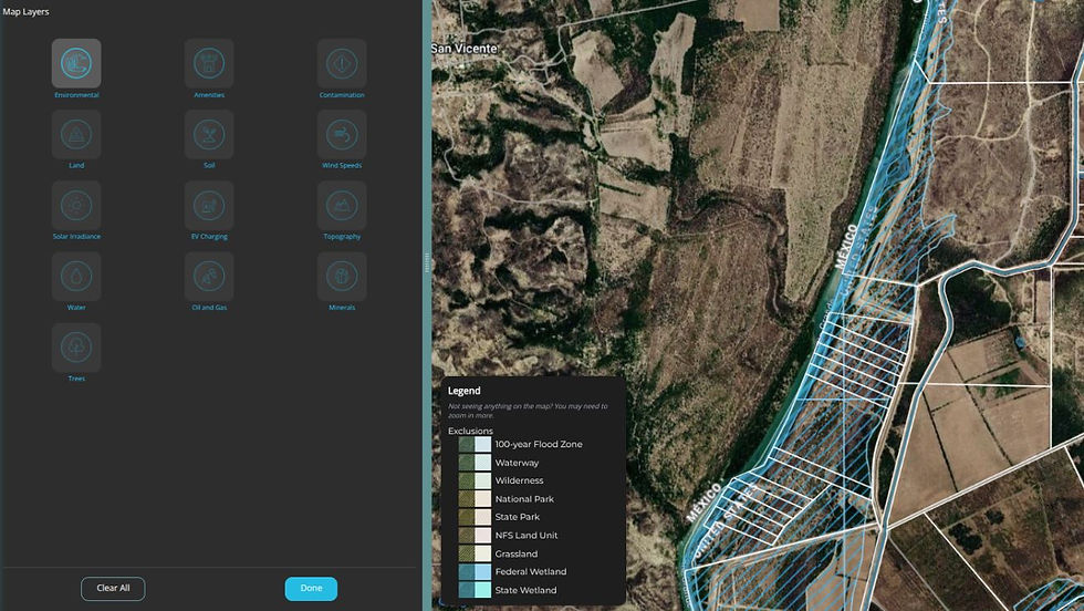
A parcel map isn't a substitute for a legal survey plan or title work when ownership is disputed, but it can provide an important starting point for understanding the property and the land around it.
The Rio Grande, Floodplains, and the International Boundary
The Rio Grande adds another layer because it serves as the international boundary through much of Texas. Unlike a boundary drawn across a fixed road or surveyed line, a river is a dynamic geographic feature. Its channel can shift, banks can erode, sediment can accumulate and flooding can reshape the surrounding landscape. As a result, the water visible on today's satellite image does not necessarily answer every question about the legal boundary of an adjacent property.
The river also creates restrictions on how border infrastructure can be designed. The United States and Mexico have agreements governing the river and structures that could affect its flow, with the International Boundary and Water Commission involved in matters concerning the international boundary and shared waters. That means a proposed barrier cannot simply be treated as a line drawn at the water's edge. In portions of the Texas border, flood-control infrastructure, roads, private properties and other features can influence where a barrier or related infrastructure can realistically be placed.
Flooding is another concern. Local officials and residents in communities along the Rio Grande have raised questions about whether new barriers and associated infrastructure could affect flood patterns, drainage and access. For landowners, the practical lesson is broader than the border itself: a property boundary is only one layer of the land. A parcel may also contain or border waterways, flood zones, wetlands and other geographic features that affect how the property is used.
Conservation Land Adds Another Layer
The border-wall debate also demonstrates why ownership is not the only property interest that matters. The Big Bend region includes Big Bend National Park, Big Bend Ranch State Park, wildlife habitat, historic sites and other environmentally and culturally significant areas. Some proposed infrastructure has therefore raised questions about environmental and cultural protections in addition to private property rights.
The October 2 injunction specifically halted construction and ground-disturbing activity across the Big Bend Sector while the court considers a lawsuit challenging federal waivers that were used to accelerate construction. The plaintiffs argued that the waivers improperly bypassed laws protecting environmental, historic and cultural resources. The court's preliminary ruling found that the plaintiffs were likely to succeed on at least one claim and could suffer irreparable harm without an injunction.
Private conservation land can create another layer of property rights. For example, a conservation easement allows the landowner to retain ownership while permanently restricting certain uses of the property for every future owner. A land trust or government entity may hold the easement and enforce its terms.
The important point for landowners and buyers is that the person listed as the property owner may not be the only party with rights connected to the land. Easements, leases, rights-of-way and other recorded interests can affect how a property can be used and how it is valued. That is true far beyond the Texas border.
State vs. Federal: Who Has the Right to Use the Land?
The dispute has also highlighted another complicated question: what happens when state and federal property interests overlap?
On July 31, Texas Land Commissioner Dawn Buckingham sent a cease-and-desist letter to CBP and federal contractor Barnard Construction, alleging that state land in Presidio County had been cleared without authorization. The General Land Office said the contractor may have had permission to cross state land under a lease, but that the lease did not authorize modifying the state's property.
The episode illustrates an important property principle: permission to cross land is not necessarily permission to alter it. A property can be subject to a surface lease, grazing lease, access easement or right-of-way while still being owned by someone else. Each document can grant different rights. When multiple property interests overlap, understanding the parcel itself is only the beginning. You also need to understand the rights attached to it.
What Are Landowners Being Asked to Sign?
Much of the current dispute centers on government requests for access to private property. The federal government has used different types of right-of-entry documents as it works to survey land, conduct assessments and move forward with border infrastructure. The U.S. Army Corps of Engineers has been handling real estate and property acquisition work for the Big Bend project, including researching title and deed records.
Right of Entry for Survey and Site Assessment
A survey and site-assessment agreement generally gives government employees or contractors temporary permission to enter property for activities such as surveying, appraisals and environmental or engineering assessments.
The key point for landowners is that temporary access is not the same thing as transferring ownership. However, the specific terms of any agreement matter. Landowners should understand where contractors can go, what activities are permitted, how long access lasts and what happens if property is damaged.
Right of Entry for Construction
A Right of Entry for Construction, or ROE-C, is broader. These agreements can provide access for construction activities while the government works through the acquisition or negotiation of the underlying property interest. Reporting on the Big Bend project indicates that some landowners have been given choices involving voluntary access, negotiation over a purchase or easement, or potential referral for condemnation if an agreement cannot be reached.
For a landowner, the most important takeaway is not that every right-of-entry agreement is the same. It is that the document should be read as a property-rights agreement, not simply a permission slip.
Before signing any document affecting your property, consider confirming:
The parcel number, acreage and boundaries identified in the document
Whether the government is requesting temporary or permanent access
Exactly what activities are authorized
Whether the agreement affects only a portion of the property
What happens to fences, wells, roads, irrigation systems and other improvements
How property damage or restoration will be handled
Whether an easement or other permanent property interest is being created
Landowners facing a government acquisition or eminent domain issue should also consult an attorney familiar with property and condemnation law.
How Eminent Domain Fits In
If a landowner and the government can't agree on a sale or easement, the government can acquire the land through condemnation. The land must be for a public use, and the owner must receive just compensation under the Fifth Amendment. For federal projects, the Declaration of Taking Act lets the government deposit its estimate of the land's value with the court and take title early, so construction can proceed while the final price is decided.
That makes property questions more important, not less. Owners need to document their parcel's legal description, survey and title history, and existing easements. They also need to know whether the government wants the entire tract or only a strip of it. On large rural tracts, a narrow strip along the river can affect the value of everything behind it. Compensation typically depends on access, water rights, highest and best use, and the effect on any land left on the far side of a barrier.
What Happens Next
The October 2 injunction pauses construction and ground-disturbing activity in the Big Bend region while the case moves forward, but it is not a final ruling, and a separate federal judge allowed construction to proceed in a different case days earlier. Additional lawsuits from landowners and other groups are pending, and the government may appeal. Border infrastructure projects elsewhere in Texas are on separate tracks.
Whatever the courts decide, the dispute has made one thing clear: large infrastructure projects succeed or stall at the parcel level. Ownership records, boundary lines, floodplain rules, easements and leases determine who must be at the table, what can be built and how much land is worth.
What the Texas Border Dispute Can Teach Landowners Everywhere
The Texas border-wall dispute may involve an unusually complex combination of federal infrastructure, international boundaries and private land, but the underlying questions are relevant to landowners everywhere:
Where exactly are my property lines?
Who owns the land around me?
What easements or rights-of-way affect the property?
Are there waterways or flood zones on or near the parcel?
Are there protected areas or other features that could affect how the land is used?
Those questions are important whether you're managing a ranch in South Texas, preparing to sell rural property in Oklahoma, evaluating land for development in Colorado or simply trying to better understand the property you already own.
The Texas dispute shows how quickly a property boundary can become the center of a much larger conversation about land rights and ownership. It also demonstrates why land research should begin with a clear understanding of the property itself and the layers of information surrounding it.
Start with your property. You don't have to be involved in a property dispute to benefit from knowing more about your land. Download LandApp for free or explore it on desktop to see your property lines, parcel boundaries and surrounding land features. With a free account, you can map geographic information to get a more complete picture of the land and create a free Property Report that covers soil types, prime farmland status, natural disaster Risk Index scores, estimated energy and carbon lease values, and nearby infrastructure. It’s a useful starting point for understanding what a property is worth and what could affect its value.
Once you've identified a property's boundaries, the next question is often ownership. Knowing who owns a neighboring parcel can provide an entirely different level of context, particularly for landowners, brokers and professionals researching large rural properties. LandApp Pro provides nationwide ownership and assessor data, allowing users to research property ownership across the country and search for properties by owner or organization name. That information can help users move beyond a visual understanding of the landscape and begin understanding the ownership structure behind it.
For a land broker, that might mean identifying the owner of a neighboring parcel while researching a potential listing. For a landowner, it could mean finding out who owns an adjacent property. For someone evaluating a potential purchase, it provides another piece of information to investigate as part of the larger due diligence process.
This article is for informational and educational purposes only and does not constitute legal advice. Landowners facing a property dispute, government acquisition, eminent domain proceeding or other legal matter should consult a qualified attorney for advice specific to their situation. LandApp's maps, data and Property Reports are intended for research and informational purposes and are not a substitute for a legal survey, title examination or professional legal advice.


