


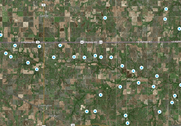
Access Precise Parcel Data & Explore Land Features with Nationwide Data Layers
Access comprehensive parcel data for over 150 million U.S. properties with LandApp Pro. Utilize LandApp's map-based data layers on a nationwide level or for specific properties. Analyze the estimated lease value of the natural resources on properties and their unique geographic features, proximity to energy grid infrastructure, buildable acreage, and more.
Nationwide Data Layers
LandApp's nationwide data layers include slope, topography, amenities, contaminated sites, tree types, soil types, water features, solar irradiance, wind speeds, mining site locations, flood zones, wetland maps, and more.
Detailed Parcel Data
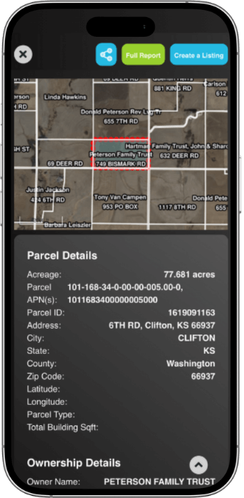
LandApp Pro gives you the ultimate edge in the competitive real estate market, allowing you to make informed decisions. Access comprehensive, detailed parcel data including ownership, building information, mailing addresses, sales/ mortgage data, and more.

Geographical Features
View property features for unlimited single-parcels with a free LandApp account. Upgrade to Pro to export unlimited Property Reports that provide comprehensive land feature data for any U.S. parcel, available on desktop and mobile.

Find Specific Properties
Find properties using an address, location, or with the geolocation feature with a free LandApp account. Upgrade to LandApp Pro to search by owner name and view property owner names on LandApp's nationwide map view.


Over 150 Million Parcels Embedded with Property Data and LandApp's Proprietary Value & Risk Index Scores
.png)
%20(1).png)
.png)
.png)
.png)
.png)
View Nationwide Data Layers with a Free LandApp Account on our Mobile App
Index Heatmaps
View value and risk index score heatmaps on a nationwide level to assess high and low-value properties and high and low-risk properties.
Environmental Data
Explore geographical land features (wetlands, water resources, flood zones, and more) and view maps of State Parks, National Parks, NFS Land Units)
Solar Irradiance
View solar irradiance levels to identify regions with high solar energy potential on a nationwide level or for specific parcels.
Amenity Data
View the exact locations of various amenities across the country (gas stations, parks, hotels, shopping centers, points of interest, campgrounds, and more).
Wind Speeds
View wind directions and wind speeds to identify regions with high wind energy potential on a nationwide level or for specific parcels.
EV Charging Data
Find the exact location of EV charging sites (Planned & Active EV charging station locations, Tesla & Non-Tesla), and view major road maps.
Land Data
Land usage across various land categories (crops, developed, barren, wetlands, grassland, forestland, developed land, water resources, and more)
Topography Data
View elevation contour lines nationwide and assess the average, minimum, and maximum slope & elevation for specific parcels.
Mineral Data
Locations of mines across the U.S. with specific data about the minerals being extracted at each location, comprehensive bedrock information
Contamination Data
View the exact location of contaminated sites, Superfund sites, abandoned oil and gas wells, and underground storage tanks across the U.S.
Soil Data
Assess soil quality, soil suitability, soil types, depth to bedrock, and prime farmland classifications nationwide or for a specific property
Water Data
View the exact locations of water wells, water dams, and aquifiers (sand and gravel, sandstone, carbonate rock, igneous and metamorphic rock, and more).
LandApp Pro: More Features

Ownership Data

Property Reports
.png)
Due Diligence
.png)
Frequently Asked Questions
With a free account, you can see high-level parcel details and propery features for unlimited properties nationwide on our mobile app. To access ownership and assessor data, upgrade to LandApp Pro.
Parcel data describes the rights, interests, and value of property. Access nationwide parcel data, like ownership and assessor information, with LandApp Pro. See property features and value indexes for unlimited parcels with a free account.
LandApp provides a value and a risk index score for each property. The value indexes reveal the highest and best use for a given property at a glance, while the risk indexes reveal any potential environmental risks compared side-by-side to state and county averages.
LandApp provides soil and bedrock data, topography, slope, land usage data, land type information, wetland maps, floodplain maps, tree type data, and more. You can also pinpoint the location of solar farms, wind farms, oil & gas wells (along with their status), contaminated sites, water wells, aquifers, mining sites, and more on a nationwide level.
The land data layer provides a land value estimate that is calculated using LandGate’s proprietary algorithms, which factor in many different data points, such as the specific types of land on a given property. If you’re looking for a land value calculator or a land value estimator tool, LandApp can help!
LandApp’s property data provides land value estimates for land and its resources. Discover solar lease estimates, wind lease estimates, carbon credit estimates, EV charging data, mining data, property features, proximity to amenities, and more for nearly every U.S. property. LandApp also features topographic maps, soil data, soil maps, electric grid maps, tree type data, contamination data, and more! LandApp's alternative energy and natural resource data is one-of-a-kind and critically important in conducting due diligence, but has never been made available until now.
No, LandApp Pro does not provide electrical grid maps. If you're looking for more in-depth data about the U.S. power grid (including available capacity, queue information, and more), check out our PowerTools subscription.
No, LandApp does not provide fiber optic data. In order to access fiber data, you must upgrade your subscription. You can learn more and book a free demo here!
Yes, you can find step-by-step guides for the Data Layers tool in LandApp Pro in our User Manual.
Yes, you can search for unlisted parcels in bulk using LandApp Pro's Parcel Search tool (on desktop only). Filter by owner name, acreage, location, proximity to amenities, Value and Risk Index Score range, and zoning. Save your searches to portfolios, located in the Parcel Data tool. To learn more, view our Parcel Search User Manual here.
Search for Unlisted Properties Nationwide & Build Portfolios
Search for unlisted properties nationwide in bulk using LandApp Pro's advanced search filters (location, acreage, owner/ organization name, proximity to amenities, value & risk index score range) in our Parcel Search tool, available on desktop only. Save your searches to portfolios that you can share with other users. Export property owner contact information ($0.09/ each) within the Parcel Data tool.
.png)
.jpg)
"Can't recommend LandApp enough. Whether you are a property owner, broker, attorney, engineer, landman, or ANYBODY that does any work involving land, LandApp makes assessing land simple, easy, interesting, and FUN."
Blake Adams
Landowner
“[LandApp] has done this great marriage of risk reduction and opportunity to find additional revenue sources that we can go transact on right here in the same moment. That is a blend that I haven’t seen any other tool do.”
Alicia Shepherd
Executive VP, KW Commercial
“There is so much great data on LandApp! This information is so important for landowners to make educated decisions when selling or leasing their property. We are also able to advertise listings to a different type of buyer than we would normally see in the local MLS's.”
Matthew Curry
Land Broker, eXp Realty
"I can set myself apart from the competition in a hurry. I'm able to generate a report on a property in seconds and give a landowner a very comprehensive report on virtually everything that matters. I could go on but I promise if you try LandApp, you'll wonder how you ever lived without it!"
Wayne Dunson
Land Broker, National Land Realty
"I listed my property on LandApp and very quickly received 12 competitive offers to lease my property for a solar project from reputable companies. After some due diligence and discussions, I was able to execute a solar lease... thanks to all the folks at LandGate!"
Joette Schalla
Landowner & Broker, Fay Ranches
"Our son Brad Belser was able to list one of our Fulton County, IL properties on the LandApp platform. We very quickly received interest in the property for a solar project from a reputable company. Without LandGate this process would not have been so easy!"
Steve & Kim Belser
Landowners
Compare Plans
Nationwide Property Data, Map Layers, and Exclusive Listings
Use LandApp and LandApp Pro on your phone and on the web. Download LandApp for free to view map-based data layers, see listings, and export 3 free Property Reports. To access ownership information, assessor data, and transaction history, upgrade to LandApp Pro.
Listings Marketplace
Feature | Free | Pro |
|---|---|---|
Apply advanced filters | ✔ | ✔ |
Value index scores on listings | ✔ | ✔ |
Property features on listings | ✔ | ✔ |
Save filters & searches | ✔ | ✔ |
New listing notifications | ✔ | ✔ |
Create unlimited listings | ✔ | ✔ |
Risk index scores on listings | ✔ |
Core Tools
Feature | Free | Pro |
|---|---|---|
PDF Property Report exports | 3 | Unlimited |
Customize Property Reports | No | Unlimited |
Draw custom maps | No | Desktop only |
Flood zone, wetlands maps | Yes | Yes |
Amenities maps | Yes | Yes |
Value and risk score heatmaps | Yes | Yes |
Contaminated site maps | Yes | Yes |
Soil type maps | Yes | Yes |
Property line maps | Yes | Yes |
Parcel Data
Feature | Free | Pro |
|---|---|---|
Parcel ID's and APN's | ✔ | ✔ |
Acreage & location details | ✔ | ✔ |
Property features (soil, topography) | ✔ | ✔ |
Value index scores | ✔ | ✔ |
Risk index scores | ✔ | |
Ownership data | ✔ | |
Assessor data | ✔ | |
Transaction data | ✔ |

The #1 Marketplace for Land & Its Resources
.png)
Looking to buy land? Whether you're searching for residential, commercial, or investment land, LandApp offers the most comprehensive land marketplace with real-time data insights. Unlike other platforms, we provide in-depth property analytics, including energy potential, natural resources, and market trends, to help you make informed decisions. Explore exclusive land for sale near you today!
