
The Strategic Survivalist: A Masterclass in Siting & Prepping for Total Self-Reliance
- Craig Kaiser
- Apr 22
- 4 min read
Updated: Apr 23

In doomsday prepping, the strength of your "Plan B" depends on its weakest link. It's essential to own one of the most advanced bunkers, such as those from Atlas Survival Shelters, and ensure it's situated in an area free from drought and wildfires. Without your own power source, your survival time diminishes.
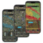
By leveraging LandApp’s advanced risk scores and environmental data, we can move beyond guesswork. This is how you use data to build a fortress that survives the "Worst-Case Scenario."
Continue reading to discover everything you need to consider before starting to dig, as well as the items your bunker should be stocked with once it's established.
1. Subsurface & Hydrology: The Foundation of Survival
The first step in siting optimal land for a survival shelter is analyzing the ground's "structural health."
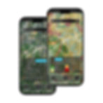
The Water Table & Corrosivity: LandApp data allows you to filter for soil acidity and moisture. High water tables create "buoyancy" issues, where hydrostatic pressure can push a multi-ton shelter out of the ground. High-corrosivity soils can compromise steel over decades. LandApp helps you find the "high and dry" spots that preserve your Atlas shelter for generations.
Potable Water Security: Survival is impossible without a dedicated water source. Use LandApp to identify properties with existing wells or proximity to deep-rock aquifers.
2. Energy Sovereignty: Powering the Post-Collapse Lifestyle
When the grid goes dark for good, "energy independence" becomes your most valuable asset. An Atlas shelter is designed to be energy-efficient, but sustaining a lifestyle underground requires a robust, renewable power strategy.
Solar Irradiance Mapping: Not all "sunny" spots are equal. LandApp provides solar irradiance data, allowing you to pinpoint the exact locations on your property with the highest photovoltaic potential. This ensures your battery banks stay topped off even during shorter winter days.
Wind Speed Analysis: For properties in northern latitudes or wooded areas where solar may be obstructed, wind is a vital secondary power source. LandApp’s wind speed layers help you determine if a micro-turbine is a viable investment for your specific ridge or valley.
Sustaining the "Bunker Life": Off-grid power isn't just for lights. It runs your NBC Air Filtration Systems, powers your deep freezers (protecting years of food), and operates your water pumps. By integrating solar and wind, you ensure that your shelter remains a "living" environment rather than just a survival box.
EMP-Proofing Your Power: Atlas offers EMP-protected shelters, and when paired with an isolated, off-grid battery array, you create a system that is immune to the cascading failures of the national grid.

3. Environmental Risk Scores: Hardening Your Perimeter, Surviving the Aftermath
LandApp provides a "Risk Profile" for every acre. Before you build, you must account for the "Invisible Threats."
Drought & Extreme Weather: Use historical data to identify regions with high drought risk scores. For long-term farming, you need land that remains resilient. Similarly, LandApp’s extreme weather layers help you avoid high-frequency tornado alleys.
Contamination & Blackout Risks: LandApp identifies "Brownfield" sites and industrial runoff zones to keep your food supply safe. Furthermore, mapping historical blackout data helps you choose a site that is already "grid-fatigued," signaling that your off-grid investment is even more necessary.
4. Forestry & Farming
A bunker is for the "event," but the land is for the "aftermath."
Arable Land Mapping: Use LandApp to check USDA Soil Survey data. Look for "Prime Farmland" designations to ensure your soil can handle high-calorie crop production.
Forestry & Hunting: LandApp’s vegetation layers identify Hardwood and Old Growth forests. These are prime habitats for large game (deer, turkey), providing a natural source of protein and renewable fuel (firewood) that doesn't require the daily maintenance of livestock.
5. Scavenging Logistics: Amenity Mapping
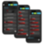
Strategic survivalists use LandApp’s Amenity Data to map out "Supply Corridors" before the world goes dark.
Target Identification: LandApp identifies the exact locations of gas stations, hardware stores, and pharmacies.
The "Tactical Range": Ideally, your property should be within a 3-day walking distance of a low-density retail cluster. This allows for stealthy supply runs for specialized needs, like antibiotics or mechanical parts, without being close enough to the city to be caught in the initial chaos.

6. Pathogen & Proxy Defense: Tactical Isolation
If the scenario involves a viral outbreak or civil unrest, "buffer zones" are your primary defense.
Population Density Heat Maps: Use LandApp to stay outside the "Golden Hour" migration zone, the distance a desperate person can travel from a city on one tank of gas.
Topographical Concealment: Strategic siting uses the natural "folds" of the land. By placing your Atlas shelter entrance behind a ridgeline or within a heavy forest canopy, you break the line of sight from drones and "high-ground" observers.
The "Perfect Site" Checklist
A property must check these seven boxes to be considered "Tactically Sound":
Feature | Requirement | Why It Matters |
Energy | High Solar/Wind Potential | Powers air filtration, food storage, and life. |
Water | Reliable Well/Aquifer | Fundamental life support and irrigation. |
Soil | Prime Arable / Low Corrosivity | Crop production and bunker longevity. |
Risk Score | Low Drought / Low Contamination | Safe food and reliable harvests. |
Forest | Hardwood / High Biodiversity | Hunting, foraging, and fuel. |
Amenities | Within Tactical Range | Access to scavenging (meds/tools). |
Location | Low Population Density | Isolation from social unrest and pathogens. |
The "Total Readiness" Checklist
Category | Requirement | Source |
Air | ||
Sanitation | Composting/Electric Toilet | |
Land Data | Soil, Water, & Risk Scores | LandApp |
Energy | Solar Irradiance & Wind Maps | LandApp |
Knowledge | Printed Medical & Hunting Books | The Analog Library |
Comm | Shortwave & Emergency Radio | The Comms Locker |
Recommended Books to have on hand:
Bushcraft series by Dave Canterbury
The Encyclopedia of Country Living by Carla Emery
Where There Is No Doctor by David Werner
Where There Is No Dentist by Murray Dickson
The Year-Round Vegetable Gardener by Niki Jabbour - the only book that will show you how to grow vegetables in winter
Bible
Auto repair for dummies
Basics of Electricity
The Complete Guide to Hunting by Steven Rinella
Books by James Wesley Rawles - one of the few "prepper" authors that actually knows his stuff
Foxfire series (full set is $245)
Books from the US Department of the Army - Soldier's manual of common tasks, Survival manual, First aid manual...
Secure Your Future
By combining the tactical engineering of Atlas Survival Shelters with the deep environmental, energy, and amenity intelligence of LandApp, you aren't just buying real estate, you are building a fortress of self-reliance.
Use LandApp to find your "Plan B" property or siting its location today.